
Thank you for supporting this site ❤️
Make a donation
Make a donation
Nayarambalam topographic map
Click on the map to display elevation.
Thank you for supporting this site ❤️
Make a donation
Make a donation
About this map
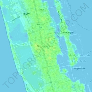
Name: Nayarambalam topographic map, elevation, terrain.
Location: Nayarambalam, Kochi, Ernakulam District, Kerala, 682509, India (10.04394 76.19485 10.08394 76.23485)
Average elevation: 3 m
Minimum elevation: -3 m
Maximum elevation: 13 m
Thank you for supporting this site ❤️
Make a donation
Make a donation
Other topographic maps
Click on a map to view its topography, its elevation and its terrain.