
Thank you for supporting this site ❤️
Make a donation
Make a donation
Greene County topographic map
Click on the map to display elevation.
Thank you for supporting this site ❤️
Make a donation
Make a donation
About this map
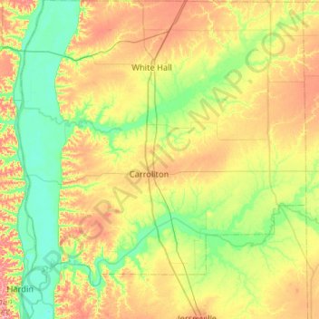
Name: Greene County topographic map, elevation, terrain.
Location: Greene County, Illinois, United States (39.11858 -90.62222 39.52153 -90.15016)
Average elevation: 168 m
Minimum elevation: 123 m
Maximum elevation: 245 m
Thank you for supporting this site ❤️
Make a donation
Make a donation
Other topographic maps
Click on a map to view its topography, its elevation and its terrain.
Sturbridge Village
United States > Illinois > Winnebago County > Sturbridge Village
Average elevation: 230 m
Thank you for supporting this site ❤️
Make a donation
Make a donation