
Thank you for supporting this site ❤️
Make a donation
Make a donation
Gorolfe topographic map
Click on the map to display elevation.
Thank you for supporting this site ❤️
Make a donation
Make a donation
About this map
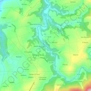
Name: Gorolfe topographic map, elevation, terrain.
Location: Gorolfe, Pascais, Samos, Sarria, Lugo, Galicia, 27620, España (42.72002 -7.37509 42.76002 -7.33509)
Average elevation: 564 m
Minimum elevation: 449 m
Maximum elevation: 806 m
Thank you for supporting this site ❤️
Make a donation
Make a donation
Other topographic maps
Click on a map to view its topography, its elevation and its terrain.
Río Lóuzara
España > Galicia > Sarria > Samos
Nace de la confluencia de varios arroyos que bajan de la Sierra de Rañadoiro, en el ayuntamiento de Piedrafita del Cebrero, entre ellos el río Louzarela. En su tramo inicial hace de límite entre los ayuntamientos de Folgoso de Caurel y de Samos para luego adentrarse en este último, por el cual discurre la…
Average elevation: 928 m
Thank you for supporting this site ❤️
Make a donation
Make a donation