
Thank you for supporting this site ❤️
Make a donation
Make a donation
Wind Gap topographic map
Click on the map to display elevation.
Thank you for supporting this site ❤️
Make a donation
Make a donation
Wind Gap
Wind Gap is located 21 miles (34 km) north of Allentown in the Lehigh Valley and 50 miles (80 km) southeast of Scranton, in the Wyoming Valley, or the Scranton/Wilkes-Barre metropolitan area. Wind Gap's elevation is 755 feet (230 m) above sea level.
Thank you for supporting this site ❤️
Make a donation
Make a donation
About this map
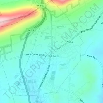
Name: Wind Gap topographic map, elevation, terrain.
Location: Wind Gap, Northampton County, Pennsylvania, United States (40.83493 -75.30521 40.86362 -75.27978)
Average elevation: 255 m
Minimum elevation: 201 m
Maximum elevation: 454 m
Thank you for supporting this site ❤️
Make a donation
Make a donation
Other topographic maps
Click on a map to view its topography, its elevation and its terrain.
Hartzells Ferry
United States > Pennsylvania > Northampton County > Upper Mount Bethel Township > Hartzells Ferry
Average elevation: 144 m