
Make a donation
Port Hedland topographic map
Click on the map to display elevation.
Make a donation
About this map
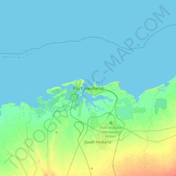
Name: Port Hedland topographic map, elevation, terrain.
Average elevation: 6 m
Minimum elevation: -1 m
Maximum elevation: 34 m
Make a donation
Other topographic maps
Click on a map to view its topography, its elevation and its terrain.
Make a donation
The Vines
Topographically, The Vines sits on a gradual incline that descends towards the Ellen Brook valley. The west of the suburb sits at 30 metres above sea level, dropping to 20 metres in the east around the brook and the Sawpit Gully.
Average elevation: 27 m
Make a donation
Make a donation
Make a donation
Make a donation
Make a donation
Make a donation
Make a donation
Make a donation
Make a donation
Exmouth
In 2009, an emergency landing of the flight Qantas 72 was made at the nearby Learmonth Airport / RAAF Base Learmonth. The A330 had an incident involving the ADIRU which confused AoA (Angle of Attack) data with altitude data, making the plane think it was in a 16° pitch up when it was flying level. So the…
Average elevation: 27 m
Make a donation
Make a donation
Make a donation
Make a donation
Make a donation
Make a donation
Make a donation
Make a donation
Make a donation
Make a donation
Make a donation
Make a donation
Make a donation
Make a donation
Make a donation