
Thank you for supporting this site ❤️
Make a donation
Make a donation
Gerbrunn topographic map
Click on the map to display elevation.
Thank you for supporting this site ❤️
Make a donation
Make a donation
About this map
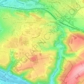
Name: Gerbrunn topographic map, elevation, terrain.
Location: Gerbrunn, Landkreis Würzburg, Beieren, 97218, Duitsland (49.77139 9.97516 49.79019 10.03296)
Average elevation: 254 m
Minimum elevation: 170 m
Maximum elevation: 338 m
Thank you for supporting this site ❤️
Make a donation
Make a donation
Other topographic maps
Click on a map to view its topography, its elevation and its terrain.
Markt Frickenhausen am Main
Duitsland > Beieren > Landkreis Würzburg > Frickenhausen a.Main
Average elevation: 246 m