
Thank you for supporting this site ❤️
Make a donation
Make a donation
Pontfadog topographic map
Click on the map to display elevation.
Thank you for supporting this site ❤️
Make a donation
Make a donation
About this map
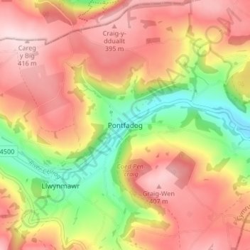
Name: Pontfadog topographic map, elevation, terrain.
Location: Pontfadog, Wrexham, Wales, LL20 7AR, United Kingdom (52.91480 -3.16074 52.95480 -3.12074)
Average elevation: 284 m
Minimum elevation: 108 m
Maximum elevation: 418 m
Thank you for supporting this site ❤️
Make a donation
Make a donation
Other topographic maps
Click on a map to view its topography, its elevation and its terrain.