
Thank you for supporting this site ❤️
Make a donation
Make a donation
Dischingen topographic map
Click on the map to display elevation.
Thank you for supporting this site ❤️
Make a donation
Make a donation
About this map
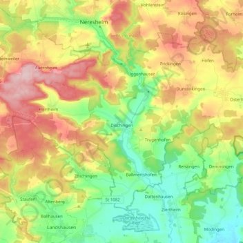
Name: Dischingen topographic map, elevation, terrain.
Average elevation: 533 m
Minimum elevation: 440 m
Maximum elevation: 657 m
Thank you for supporting this site ❤️
Make a donation
Make a donation
Other topographic maps
Click on a map to view its topography, its elevation and its terrain.
Nördlinger Stein
Germany > Baden-Württemberg > Landkreis Heidenheim > Königsbronn > Zahnberg
Average elevation: 586 m
Schnaitheim
Germany > Baden-Württemberg > Landkreis Heidenheim > Heidenheim an der Brenz
Average elevation: 551 m
Schnepfenstand
Germany > Baden-Württemberg > Landkreis Heidenheim > Herbrechtingen
Average elevation: 574 m
Thank you for supporting this site ❤️
Make a donation
Make a donation
Hitzingsweiler
Germany > Baden-Württemberg > Landkreis Heidenheim > Königsbronn
Average elevation: 639 m