
Thank you for supporting this site ❤️
Make a donation
Make a donation
Bigrolle topographic map
Click on the map to display elevation.
Thank you for supporting this site ❤️
Make a donation
Make a donation
About this map
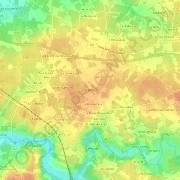
Name: Bigrolle topographic map, elevation, terrain.
Average elevation: 29 m
Minimum elevation: 3 m
Maximum elevation: 43 m
Thank you for supporting this site ❤️
Make a donation
Make a donation
Other topographic maps
Click on a map to view its topography, its elevation and its terrain.
Sèvre Nantaise
France > Pays de la Loire > Loire-Atlantique > Le Pallet > Le Perray
Average elevation: 28 m