
Thank you for supporting this site ❤️
Make a donation
Make a donation
Grande-Digue topographic map
Click on the map to display elevation.
Thank you for supporting this site ❤️
Make a donation
Make a donation
About this map
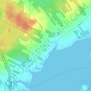
Name: Grande-Digue topographic map, elevation, terrain.
Average elevation: 13 m
Minimum elevation: -2 m
Maximum elevation: 45 m
Thank you for supporting this site ❤️
Make a donation
Make a donation
Other topographic maps
Click on a map to view its topography, its elevation and its terrain.
Cocagne
Canada > New Brunswick > Rural Community of Beausoleil > Dundas Parish
Average elevation: 18 m