
Make a donation
Capo d'Orlando topographic map
Click on the map to display elevation.
Make a donation
Capo d'Orlando
A large part of the town is mainly located on a narrow plain, enclosed between the sea and a hill range which extends parallel to it. Here, various frazioni are located: San Martino (the most populated), Scafa, Piscittina, Forno Alto, Catutè, Certari e Malvicino, all are located at between 50 and 300m of altitude. On the western side, the frazioni of Forno Medio, Trazzera Marina, Piana, Furriolo, Bruca, Vina, Masseria, San Giuseppe and Tavola Grande are located. On the eastern coastline we can find the village of San Gregorio (Borgo di San Gregorio), in addition to the seaside area called Testa di Monaco, bordering the comune of Naso.
Make a donation
About this map
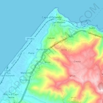
Name: Capo d'Orlando topographic map, elevation, terrain.
Location: Capo d'Orlando, Messina, Sicily, 98071, Italy (38.10807 14.70546 38.16601 14.79140)
Average elevation: 151 m
Minimum elevation: 0 m
Maximum elevation: 579 m
Make a donation
Other topographic maps
Click on a map to view its topography, its elevation and its terrain.
Make a donation
Make a donation
Make a donation
Make a donation
Make a donation
Make a donation