
Thank you for supporting this site ❤️
Make a donation
Make a donation
Beringen topographic map
Click on the map to display elevation.
Thank you for supporting this site ❤️
Make a donation
Make a donation
Beringen
Eine nicht vollständig asphaltierte Nebenstrasse führt von Beringen über einen kleinen Höhenzug zum Quartier Breite der Stadt Schaffhausen. Diese Strasse wird auch der Kistenpass genannt, da sie über einen Hohen Punkt auf dem Randen führt.
Thank you for supporting this site ❤️
Make a donation
Make a donation
About this map
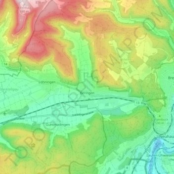
Name: Beringen topographic map, elevation, terrain.
Location: Beringen, Schaffhausen, 8222, Schweiz (47.66704 8.54208 47.73250 8.60823)
Average elevation: 546 m
Minimum elevation: 354 m
Maximum elevation: 858 m
Thank you for supporting this site ❤️
Make a donation
Make a donation
Other topographic maps
Click on a map to view its topography, its elevation and its terrain.