
São Jorge topographic map
Interactive map
Click on the map to display elevation.
About this map
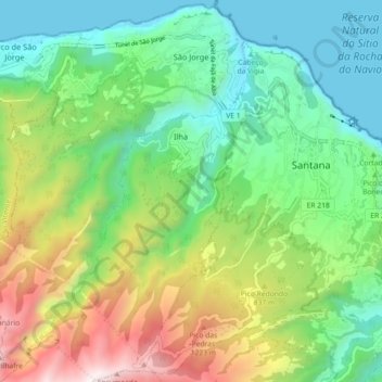
Name: São Jorge topographic map, elevation, terrain.
Location: São Jorge, Santana, Madeira, 9230-142, Portugal (32.76174 -16.96055 32.83761 -16.89639)
Average elevation: 581 m
Minimum elevation: -1 m
Maximum elevation: 1,767 m
Im Nordosten der Gemeinde liegt auf einem weit ins Meer ragenden Felsvorsprung der 1959 gebaute Leuchtturm Farol da Ponta de São Jorge auf einer Höhe von 257 Metern.