
Mukteshwar topographic map
Interactive map
Click on the map to display elevation.
About this map
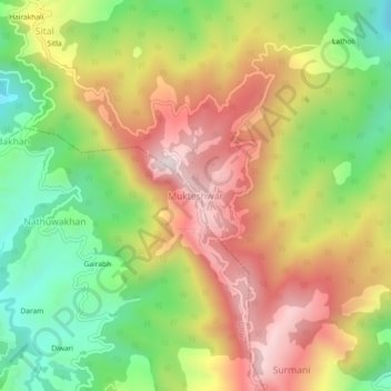
Name: Mukteshwar topographic map, elevation, terrain.
Average elevation: 1,982 m
Minimum elevation: 1,653 m
Maximum elevation: 2,323 m
Other topographic maps
Click on a map to view its topography, its elevation and its terrain.
Chaukhuta
India > Uttarakhand > Dhari > Kasiyalekh
Chaukhuta, Kasiyalekh, Dhari, Nainital District, Uttarakhand, 263132, India
Average elevation: 1,963 m
Mornaula
India > Uttarakhand > Dhari
Mornaula, Dhari, Nainital District, Uttarakhand, India
Average elevation: 1,974 m
Bhareliya
India > Uttarakhand > Dhari > Bhateliya
Bhareliya, Bhateliya, Dhari, Nainital, Uttarakhand, 263132, India
Average elevation: 1,995 m