
Thank you for supporting this site ❤️
Make a donation
Make a donation
Ashland topographic map
Click on the map to display elevation.
Thank you for supporting this site ❤️
Make a donation
Make a donation
About this map
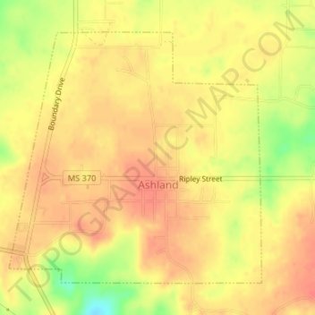
Name: Ashland topographic map, elevation, terrain.
Location: Ashland, Benton County, Mississippi, United States (34.82440 -89.19149 34.84594 -89.16512)
Average elevation: 185 m
Minimum elevation: 148 m
Maximum elevation: 201 m
Thank you for supporting this site ❤️
Make a donation
Make a donation
Other topographic maps
Click on a map to view its topography, its elevation and its terrain.