
Outeiro topographic map
Interactive map
Click on the map to display elevation.
About this map
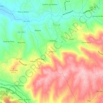
Name: Outeiro topographic map, elevation, terrain.
Location: Outeiro, Vila Cã, Pombal, Leiria, Portugal (39.83174 -8.58703 39.87174 -8.54703)
Average elevation: 196 m
Minimum elevation: 97 m
Maximum elevation: 303 m
Other topographic maps
Click on a map to view its topography, its elevation and its terrain.
Chão do Ulmeiro
Portugal > Leiria > Pombal > Vila Cã
Chão do Ulmeiro, Vila Cã, Pombal, Leiria, Portugal
Average elevation: 268 m