
Make a donation
Sarceaux topographic map
Click on the map to display elevation.
Make a donation
Sarceaux
Sarceaux se serait formé à partir du latin circellus (« petit cercle ») et évoquerait une courbure, un terrain ou une agglomération en courbe. La topographie du lieu est marquée par la courbe régulière que forme l'Orne et son affluent la Baize ainsi que par le relief en abord, mais on ne peut pas affirmer que cette étymologie en résulte.
Make a donation
About this map
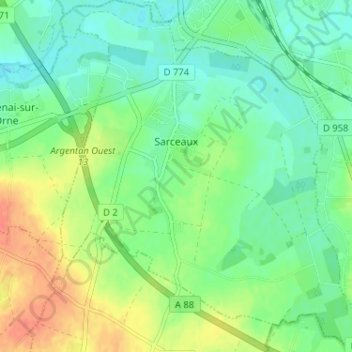
Name: Sarceaux topographic map, elevation, terrain.
Average elevation: 165 m
Minimum elevation: 149 m
Maximum elevation: 192 m
Make a donation
Other topographic maps
Click on a map to view its topography, its elevation and its terrain.
Make a donation
Les Milles Mottes
France > Normandie > Orne > Bagnoles-de-l'Orne-Normandie > Bagnoles-de-l'Orne
Average elevation: 191 m
Make a donation
Make a donation
Make a donation
Make a donation
La Bunodière
France > Normandie > Orne > Athis-Val-de-Rouvre > Athis-de-l'Orne
Average elevation: 218 m
Lac de Rabodanges
France > Normandie > Orne > Putanges-le-Lac > Sainte-Croix-sur-Orne
Average elevation: 176 m
Make a donation
Make a donation
Le Gros Chene
France > Normandie > Orne > Rives-d'Andaine > La Chapelle-d'Andaine
Average elevation: 201 m
Carrefour des Quatre Arpents
France > Normandie > Orne > Saint-Nicolas-des-Bois
Average elevation: 350 m
Make a donation
Make a donation
La Chauviniere
France > Normandie > Orne > Athis-Val-de-Rouvre > Athis-de-l'Orne
Average elevation: 235 m
Make a donation
Make a donation
Haras National du Pin
France > Normandie > Orne > Le Pin-au-Haras > Pontavice
Average elevation: 203 m
Make a donation
Make a donation
Make a donation
La Bagotière
France > Normandie > Orne > Athis-Val-de-Rouvre > Ségrie-Fontaine
Average elevation: 152 m
Make a donation
La Coignière
France > Normandie > Orne > Rives-d'Andaine > La Chapelle-d'Andaine
Average elevation: 159 m
Le Defais
France > Normandie > Orne > Domfront en Poiraie > La Haute-Chapelle
Average elevation: 183 m
Make a donation
Make a donation
Le Cauche de la Sapaie
France > Normandie > Orne > Saint-Symphorien-des-Bruyères
Average elevation: 258 m
Make a donation
Make a donation
Moulicent
France > Normandie > Orne > Longny les Villages
Moulicent est un village de l'Orne dans la région de Basse-Normandie qui fait partie du canton de Longny-au-Perche. Située dans le Perche entre 170 et 246 mètres d'altitude et voisine des communes de Longny-au-Perche et de Marchainville, sa superficie est de 33,41 km².
Average elevation: 219 m
Make a donation
Make a donation
Make a donation
Les Martellières
France > Normandie > Orne > Juvigny-Val-d'Andaine > Sept-Forges
Average elevation: 125 m
Make a donation
Make a donation
Make a donation