
Thank you for supporting this site ❤️
Make a donation
Make a donation
Pata Pampa topographic map
Click on the map to display elevation.
Thank you for supporting this site ❤️
Make a donation
Make a donation
About this map
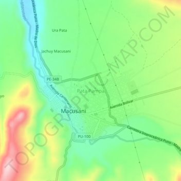
Name: Pata Pampa topographic map, elevation, terrain.
Location: Pata Pampa, Macusani, Carabaya, Puno, 30023, Perú (-14.08399 -70.44743 -14.04399 -70.40743)
Average elevation: 4,361 m
Minimum elevation: 4,271 m
Maximum elevation: 4,514 m
Thank you for supporting this site ❤️
Make a donation
Make a donation
Other topographic maps
Click on a map to view its topography, its elevation and its terrain.