
Thank you for supporting this site ❤️
Make a donation
Make a donation
Kastneshamn topographic map
Click on the map to display elevation.
Thank you for supporting this site ❤️
Make a donation
Make a donation
About this map
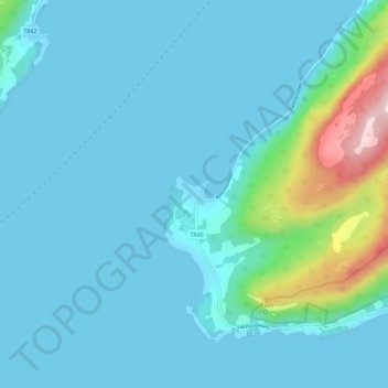
Name: Kastneshamn topographic map, elevation, terrain.
Location: Kastneshamn, Dyrøy, Troms og Finnmark, Norway (68.97487 17.46388 69.01487 17.50388)
Average elevation: 50 m
Minimum elevation: 0 m
Maximum elevation: 411 m
Thank you for supporting this site ❤️
Make a donation
Make a donation
Other topographic maps
Click on a map to view its topography, its elevation and its terrain.
Thank you for supporting this site ❤️
Make a donation
Make a donation
Thank you for supporting this site ❤️
Make a donation
Make a donation