
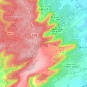
Hattonchâtel topographic map
Interactive map
Click on the map to display elevation.
About this map
Name: Hattonchâtel topographic map, elevation, terrain.
Average elevation: 327 m
Minimum elevation: 227 m
Maximum elevation: 416 m
Le village est situé sur un éperon rocheux à une altitude de 355 m, et domine de 80 m la plaine de la Woëvre et le lac de Madine.
Other topographic maps
Click on a map to view its topography, its elevation and its terrain.
Hattonville
France > Grand Est > Meuse > Vigneulles-lès-Hattonchâtel
Hattonville, Vigneulles-lès-Hattonchâtel, Commercy, Meuse, Grand Est, France métropolitaine, 55210, France
Average elevation: 238 m
Vigneulles-lès-Hattonchâtel
France > Grand Est > Meuse > Vigneulles-lès-Hattonchâtel
Vigneulles-lès-Hattonchâtel, Commercy, Meuse, Grand Est, France métropolitaine, 55210, France
Average elevation: 243 m
Cochonville
France > Grand Est > Meuse > Vigneulles-lès-Hattonchâtel
Cochonville, Vigneulles-lès-Hattonchâtel, Commercy, Meuse, Grand Est, France métropolitaine, 55210, France
Average elevation: 270 m