
Thank you for supporting this site ❤️
Make a donation
Make a donation
Skyros topographic map
Click on the map to display elevation.
Thank you for supporting this site ❤️
Make a donation
Make a donation
About this map
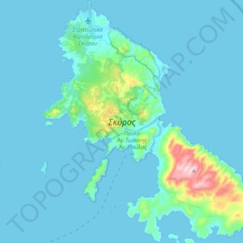
Name: Skyros topographic map, elevation, terrain.
Average elevation: 61 m
Minimum elevation: 0 m
Maximum elevation: 781 m
Thank you for supporting this site ❤️
Make a donation
Make a donation
Other topographic maps
Click on a map to view its topography, its elevation and its terrain.
Eretria
Greece > Central Greece > Euboea Regional Unit > Eretria Municipal Unit
Average elevation: 45 m
Thank you for supporting this site ❤️
Make a donation
Make a donation