
Braunschweiger Hütte topographic map
Interactive map
Click on the map to display elevation.
Braunschweiger Hütte
Auf Fahrweg am Ende des Pitztals entlang der Pitze ins Gries bis zur Talstation der Materialseilbahn (am Gletscherstübele) und von dort auf markiertem Steig zur Hütte. Für die rund 1.000 Höhenmeter rechnet man eine Gehzeit von ca. 3 Stunden. Mit der Materialseilbahn ist der Gepäcktransport möglich.
About this map
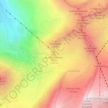
Name: Braunschweiger Hütte topographic map, elevation, terrain.
Average elevation: 2,693 m
Minimum elevation: 1,880 m
Maximum elevation: 3,336 m
Other topographic maps
Click on a map to view its topography, its elevation and its terrain.
Weißwald
Österreich > Tirol > Gemeinde St. Leonhard im Pitztal > Plangeross > Weißwald
Average elevation: 2,165 m