
Thank you for supporting this site ❤️
Make a donation
Make a donation
Murphy City topographic map
Click on the map to display elevation.
Thank you for supporting this site ❤️
Make a donation
Make a donation
About this map
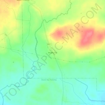
Name: Murphy City topographic map, elevation, terrain.
Average elevation: 569 m
Minimum elevation: 540 m
Maximum elevation: 611 m
Thank you for supporting this site ❤️
Make a donation
Make a donation
Other topographic maps
Click on a map to view its topography, its elevation and its terrain.
Boundary Waters Canoe Area Wilderness
United States > Minnesota > Lake County
Average elevation: 423 m
Thank you for supporting this site ❤️
Make a donation
Make a donation
Thank you for supporting this site ❤️
Make a donation
Make a donation