
Thank you for supporting this site ❤️
Make a donation
Make a donation
Coral Gables topographic map
Click on the map to display elevation.
Thank you for supporting this site ❤️
Make a donation
Make a donation
About this map
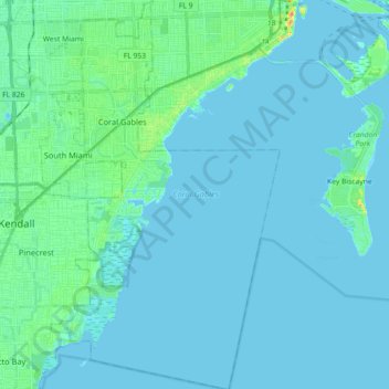
Name: Coral Gables topographic map, elevation, terrain.
Location: Coral Gables, Miami-Dade County, Florida, United States (25.60999 -80.30130 25.77177 -80.19563)
Average elevation: 5 m
Minimum elevation: -1 m
Maximum elevation: 30 m
Thank you for supporting this site ❤️
Make a donation
Make a donation
Other topographic maps
Click on a map to view its topography, its elevation and its terrain.
Miami Canal
United States > Florida > Miami-Dade County > Miami > Fronton Trailer Park
Average elevation: 7 m
Legion Park
United States > Florida > Miami-Dade County > Miami > Edison Center
Average elevation: 9 m