
Thank you for supporting this site ❤️
Make a donation
Make a donation
Abercynon topographic map
Click on the map to display elevation.
Thank you for supporting this site ❤️
Make a donation
Make a donation
About this map
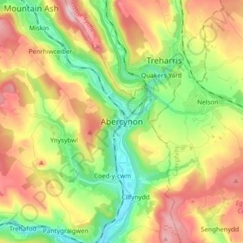
Name: Abercynon topographic map, elevation, terrain.
Location: Abercynon, Rhondda Cynon Taf, Wales, CF45 4RE, United Kingdom (51.60490 -3.36836 51.68490 -3.28836)
Average elevation: 210 m
Minimum elevation: 58 m
Maximum elevation: 410 m
Thank you for supporting this site ❤️
Make a donation
Make a donation
Other topographic maps
Click on a map to view its topography, its elevation and its terrain.
Thank you for supporting this site ❤️
Make a donation
Make a donation
Thank you for supporting this site ❤️
Make a donation
Make a donation