
Thank you for supporting this site ❤️
Make a donation
Make a donation
Kaufungen topographic map
Click on the map to display elevation.
Thank you for supporting this site ❤️
Make a donation
Make a donation
About this map
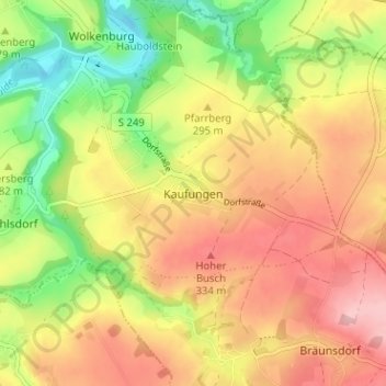
Name: Kaufungen topographic map, elevation, terrain.
Location: Kaufungen, Limbach-Oberfrohna, Zwickau, Sachsen, Deutschland (50.86780 12.66685 50.90780 12.70685)
Average elevation: 287 m
Minimum elevation: 208 m
Maximum elevation: 356 m
Thank you for supporting this site ❤️
Make a donation
Make a donation
Other topographic maps
Click on a map to view its topography, its elevation and its terrain.
FFH Mittleres Zwickauer Muldetal (Teilfläche 4: Wiese bei Bräunsdorf)
Deutschland > Sachsen > Zwickau > Limbach-Oberfrohna > Bräunsdorf
Average elevation: 326 m