
Delta County topographic map
Interactive map
Click on the map to display elevation.
About this map
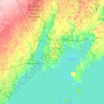
Name: Delta County topographic map, elevation, terrain.
Location: Delta County, Michigan, États-Unis (45.47733 -87.36765 46.15910 -86.45908)
Average elevation: 210 m
Minimum elevation: 172 m
Maximum elevation: 334 m
Other topographic maps
Click on a map to view its topography, its elevation and its terrain.
Pontiac
États-Unis > Michigan > Pontiac
Pontiac, Oakland County, Michigan, États-Unis
Average elevation: 290 m
Oakland Charter Township
États-Unis > Michigan > Oakland Charter Township
Oakland Charter Township, Oakland County, Michigan, États-Unis
Average elevation: 284 m