Geolocate
👉 Easily get elevation data in JSON, GeoTIFF and KML formats using Elevation API
Thank you for supporting this site ❤️
Make a donation

Jigani topographic map

Click on the map to display elevation.

👉 Easily get elevation data in JSON, GeoTIFF and KML formats using Elevation API
Thank you for supporting this site ❤️
Make a donation

About this map

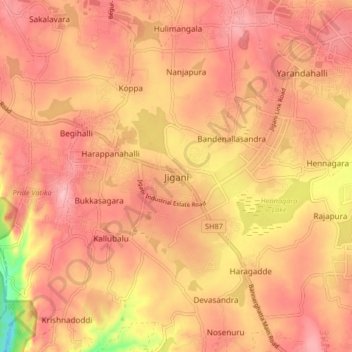
Name: Jigani topographic map, elevation, terrain.

Location: Jigani, Anekal, Bengaluru Urban, Karnataka, 560105, India (12.74525 77.59809 12.82525 77.67809)

Average elevation: 906 m

Minimum elevation: 804 m

Maximum elevation: 949 m

Other topographic maps

Click on a map to view its topography, its elevation and its terrain.

Choodasandra

India > Karnataka > Anekal > Choodasandra

Average elevation: 903 m

Bikkanahalli

India > Karnataka > Anekal

Average elevation: 885 m

Chikkanagamangala

India > Karnataka > Anekal > Gattahalli

Average elevation: 910 m

Kambalipura

India > Karnataka > Anekal > Kambalipura

Average elevation: 886 m

Yamare

India > Karnataka > Anekal > Yamare

Average elevation: 890 m

Harlur Lake

India > Karnataka > Anekal > Bengaluru

Average elevation: 904 m