
Thank you for supporting this site ❤️
Make a donation
Make a donation
Hallgurd mountain topographic map
Click on the map to display elevation.
Thank you for supporting this site ❤️
Make a donation
Make a donation
Hallgurd mountain
Halgurd (Kurdish: Helgurd ,هەڵگورد) is the second highest mountain in Iraq, after Cheekha Dar, and the tallest fully within Iraq. Located in Choman district in Northern Erbil Province, Kurdistan Region, Iraq, Halgurd has an elevation of 3,607 metres.
Thank you for supporting this site ❤️
Make a donation
Make a donation
About this map
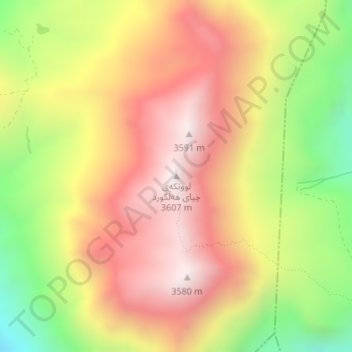
Name: Hallgurd mountain topographic map, elevation, terrain.
Average elevation: 3,130 m
Minimum elevation: 2,551 m
Maximum elevation: 3,592 m
Thank you for supporting this site ❤️
Make a donation
Make a donation
Other topographic maps
Click on a map to view its topography, its elevation and its terrain.
Thank you for supporting this site ❤️
Make a donation
Make a donation
Thank you for supporting this site ❤️
Make a donation
Make a donation
Thank you for supporting this site ❤️
Make a donation
Make a donation
Thank you for supporting this site ❤️
Make a donation
Make a donation
Thank you for supporting this site ❤️
Make a donation
Make a donation
Thank you for supporting this site ❤️
Make a donation
Make a donation
Thank you for supporting this site ❤️
Make a donation
Make a donation