
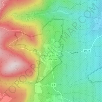
Husseren-les-Châteaux topographic map
Interactive map
Click on the map to display elevation.
About this map
Name: Husseren-les-Châteaux topographic map, elevation, terrain.
Average elevation: 398 m
Minimum elevation: 220 m
Maximum elevation: 670 m
Other topographic maps
Click on a map to view its topography, its elevation and its terrain.
Burnhaupt-le-Haut
France > Grand Est > Haut-Rhin
Burnhaupt-le-Haut, Thann-Guebwiller, Haut-Rhin, Grand Est, Metropolitan France, 68520, France
Average elevation: 308 m
Le Bonhomme
France > Grand Est > Haut-Rhin
Le Bonhomme, Colmar-Ribeauvillé, Haut-Rhin, Grand Est, Metropolitan France, 68650, France
Average elevation: 904 m