
Thank you for supporting this site ❤️
Make a donation
Make a donation
Pa' Matung topographic map
Click on the map to display elevation.
Thank you for supporting this site ❤️
Make a donation
Make a donation
About this map
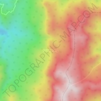
Name: Pa' Matung topographic map, elevation, terrain.
Location: Pa' Matung, Nunukan, North Kalimantan, Kalimantan, Indonesia (3.72412 115.89652 3.76412 115.93652)
Average elevation: 1,294 m
Minimum elevation: 840 m
Maximum elevation: 1,677 m
Thank you for supporting this site ❤️
Make a donation
Make a donation
Other topographic maps
Click on a map to view its topography, its elevation and its terrain.