
Thank you for supporting this site ❤️
Make a donation
Make a donation
Grand Coulee topographic map
Click on the map to display elevation.
Thank you for supporting this site ❤️
Make a donation
Make a donation
About this map
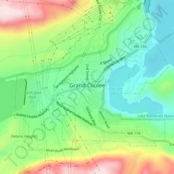
Name: Grand Coulee topographic map, elevation, terrain.
Location: Grand Coulee, Grant County, Washington, United States (47.93140 -119.02023 47.95110 -118.98451)
Average elevation: 502 m
Minimum elevation: 371 m
Maximum elevation: 723 m
Thank you for supporting this site ❤️
Make a donation
Make a donation
Other topographic maps
Click on a map to view its topography, its elevation and its terrain.