
Thank you for supporting this site ❤️
Make a donation
Make a donation
Grintovec topographic map
Click on the map to display elevation.
Thank you for supporting this site ❤️
Make a donation
Make a donation
Grintovec
Grintovec is the highest mountain of the Kamnik–Savinja Alps, with an elevation of 2,558 metres (8,392 ft). It is a popular location for hiking, climbing and skiing. The first recorded ascent was in 1759 by the botanist Giovanni Antonio Scopoli.
Thank you for supporting this site ❤️
Make a donation
Make a donation
About this map
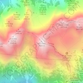
Name: Grintovec topographic map, elevation, terrain.
Location: Grintovec, Kamnik, Upravna Enota Kamnik, Slovenia (46.35708 14.53535 46.35718 14.53545)
Average elevation: 1,959 m
Minimum elevation: 1,228 m
Maximum elevation: 2,538 m
Thank you for supporting this site ❤️
Make a donation
Make a donation