
Make a donation
Mount Graham topographic map
Click on the map to display elevation.
Make a donation
About this map
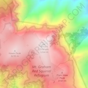
Name: Mount Graham topographic map, elevation, terrain.
Location: Mount Graham, Graham County, Arizona, United States (32.70159 -109.87144 32.70169 -109.87134)
Average elevation: 2,957 m
Minimum elevation: 2,446 m
Maximum elevation: 3,260 m
Make a donation
Other topographic maps
Click on a map to view its topography, its elevation and its terrain.
Safford
United States > Arizona > Graham County
The climate is cold semi-arid (Köppen: BSk) softened by the plateau rise (it receives enough rainfall not to fall into a cold desert, BWk). It is much hotter than most places in eastern Arizona due to its relatively low elevation of 2,953 feet (900 m) at the Agricultural Center where records are kept, and…
Average elevation: 912 m
Safford
United States > Arizona > Graham County
The climate is hot semi-arid (Köppen: BSh) softened by the plateau rise (it receives enough rainfall not to fall into a hot desert, BWh). It is much hotter than most places in eastern Arizona due to its relatively low elevation of 2,953 feet (900 m) at the Agricultural Center where records are kept, and often…
Average elevation: 911 m