
Thank you for supporting this site ❤️
Make a donation
Make a donation
Nothomb topographic map
Click on the map to display elevation.
Thank you for supporting this site ❤️
Make a donation
Make a donation
About this map
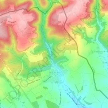
Name: Nothomb topographic map, elevation, terrain.
Location: Nothomb, Attert, Arlon, Luxembourg, Wallonie, 6717, Belgique (49.75963 5.74937 49.79665 5.80846)
Average elevation: 383 m
Minimum elevation: 296 m
Maximum elevation: 481 m
Thank you for supporting this site ❤️
Make a donation
Make a donation
Other topographic maps
Click on a map to view its topography, its elevation and its terrain.
Messancy
Belgique > Luxembourg > Arlon > Messancy > Messancy
D'après les relevés des cartes IGN no 71/3-4, le point le plus élevé de la commune se situe entre Turpange et Sélange à 410 mètres d'altitude sur le versant gauche du ruisseau de la Messancy, au lieu-dit Kiirchbierg ; sur le versant droit, le point le plus élevé s'élève à 375 mètres, entre…
Average elevation: 320 m
Thank you for supporting this site ❤️
Make a donation
Make a donation