
Make a donation
La Marina topographic map
Click on the map to display elevation.
Make a donation
About this map
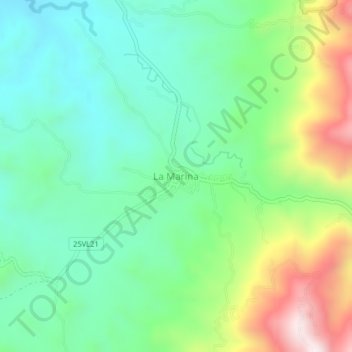
Name: La Marina topographic map, elevation, terrain.
Location: La Marina, Centro, Valle del Cauca, Colombia (4.02592 -76.13356 4.06592 -76.09356)
Average elevation: 1,352 m
Minimum elevation: 1,136 m
Maximum elevation: 1,825 m
Make a donation
Other topographic maps
Click on a map to view its topography, its elevation and its terrain.
Cali
Under Köppen's climate classification, Cali features a dry-summer tropical savanna climate (Köppen climate classification: As), closely bordering a tropical monsoon climate (Köppen: Am). The Western Mountain Range rises from an average of 2,000 m (6,562 ft) above sea level in the northern part of the city…
Average elevation: 1,286 m
Cali
Under Köppen's climate classification, Cali features a dry-summer tropical savanna climate (Köppen climate classification: As), closely bordering a tropical monsoon climate (Köppen: Am). The Western Mountain Range rises from an average of 2,000 m (6,562 ft) above sea level in the northern part of the city…
Average elevation: 1,284 m
Cali
Under Köppen's climate classification, Cali features a dry-summer tropical savanna climate (Köppen climate classification: As). The Western Mountain Range rises from an average of 2,000 m (6,562 ft) above sea level in the northern part of the city to approximately 4,000 m (13,123 ft) to the south. Because of…
Average elevation: 1,284 m
Make a donation
Cali
Colombia > Valle del Cauca > Cali
Under Köppen's climate classification, Cali features a dry-summer tropical monsoon climate (Köppen climate classification: Am), bordering a tropical savanna climate (Köppen: As). The Western Mountain Range rises from an average of 2,000 m (6,562 ft) above sea level in the northern part of the city to…
Average elevation: 1,140 m
Make a donation
Cali
Under Köppen's climate classification, Cali features a dry-summer tropical monsoon climate (Köppen climate classification: Am), bordering a tropical savanna climate (Köppen: As). The Western Mountain Range rises from an average of 2,000 m (6,562 ft) above sea level in the northern part of the city to…
Average elevation: 1,284 m
Make a donation
Cali
Under Köppen's climate classification, Cali features a dry-summer tropical monsoon climate (Köppen climate classification: Am), bordering a tropical savanna climate (Köppen: As). The Western Mountain Range rises from an average of 2,000 m (6,562 ft) above sea level in the northern part of the city to…
Average elevation: 1,284 m
Make a donation
Yumbo
Yumbo has a relatively dry but extremely foggy and sunless tropical savanna climate (Köppen Aw) not unlike the climate of Bogotá except substantially hotter due to the lower elevation.
Average elevation: 1,251 m
Cali
Under Köppen's climate classification, Cali features a dry-summer tropical monsoon climate (Köppen climate classification: Am), bordering a tropical savanna climate (Köppen: As). The Western Mountain Range rises from an average of 2,000 m (6,562 ft) above sea level in the northern part of the city to…
Average elevation: 1,572 m
Make a donation
Make a donation
Cali
Under Köppen's climate classification, Cali features a dry-summer tropical savanna climate (Köppen climate classification: As). The Western Mountain Range rises from an average of 2,000 m (6,562 ft) above sea level in the northern part of the city to approximately 4,000 m (13,123 ft) to the south. Because of…
Average elevation: 1,284 m
Cali
Colombia > Valle del Cauca > Cali
Under Köppen's climate classification, Cali features a dry-summer tropical savanna climate (Köppen climate classification: As). The Western Mountain Range rises from an average of 2,000 m (6,562 ft) above sea level in the northern part of the city to approximately 4,000 m (13,123 ft) to the south. Because of…
Average elevation: 1,142 m
Make a donation
Cali
Colombia > Valle del Cauca > Cali
Under Köppen's climate classification, Cali features a dry-summer tropical savanna climate (Köppen climate classification: As). The Western Mountain Range rises from an average of 2,000 m (6,562 ft) above sea level in the northern part of the city to approximately 4,000 m (13,123 ft) to the south. Because of…
Average elevation: 1,140 m
Palmira
Palmira is located in southwestern Colombia, lying in the Cauca River valley. 3°31’48” north altitude and 76°81’13” longitude west of Greenwich. The city covers an area of 1,160 km2 (448 sq mi). The city lies at an elevation of 1,000 m (3,300 ft) above sea level.
Average elevation: 1,600 m
Make a donation