
Thank you for supporting this site ❤️
Make a donation
Make a donation
Al Mawasi` topographic map
Click on the map to display elevation.
Thank you for supporting this site ❤️
Make a donation
Make a donation
About this map
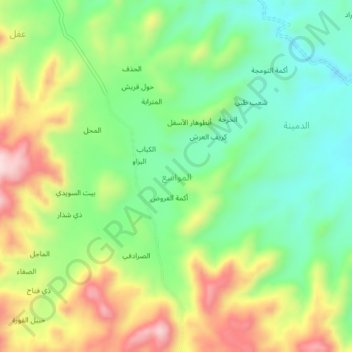
Name: Al Mawasi` topographic map, elevation, terrain.
Location: Al Mawasi`, As Sabrah District, Ibb Governorate, Yemen (13.82784 44.29265 13.86784 44.33265)
Average elevation: 1,656 m
Minimum elevation: 1,521 m
Maximum elevation: 1,864 m
Thank you for supporting this site ❤️
Make a donation
Make a donation
Other topographic maps
Click on a map to view its topography, its elevation and its terrain.