
Ringwood topographic map
Click on the map to display elevation.
About this map
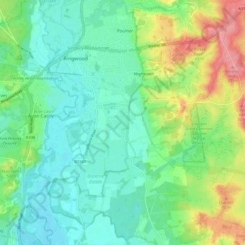
Name: Ringwood topographic map, elevation, terrain.
Location: Ringwood, New Forest, Hampshire, England, United Kingdom (50.79615 -1.81214 50.86265 -1.73266)
Average elevation: 34 m
Minimum elevation: 6 m
Maximum elevation: 96 m
Other topographic maps
Click on a map to view its topography, its elevation and its terrain.
South Baddesley
United Kingdom > England > Hampshire > New Forest > Norleywood
Average elevation: 13 m
Warwick Slade
United Kingdom > England > Hampshire > New Forest > Lyndhurst > Allum Green
Average elevation: 36 m
Newbridge Inclosure
United Kingdom > England > Hampshire > New Forest > Copythorne
Average elevation: 29 m
Bickton
United Kingdom > England > Hampshire > New Forest > Fordingbridge > Bickton
Average elevation: 39 m
Monkton Mead
United Kingdom > England > Hampshire > New Forest > Breamore > South Charford
Average elevation: 52 m