
Walker County topographic map
Interactive map
Click on the map to display elevation.
About this map
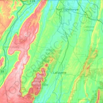
Name: Walker County topographic map, elevation, terrain.
Location: Walker County, Georgia, USA (34.58640 -85.53433 34.98507 -85.05226)
Average elevation: 333 m
Minimum elevation: 197 m
Maximum elevation: 696 m
Other topographic maps
Click on a map to view its topography, its elevation and its terrain.
Chattahoochee Bend State Park
Chattahoochee Bend State Park, Coweta County, Georgia, USA
Average elevation: 238 m
Orange Springs
USA > Georgia > Orange Springs
Orange Springs, Grady County, Georgia, 31797, USA
Average elevation: 78 m
Cameron Point
USA > Georgia > Cameron Point
Cameron Point, Hall County, Georgia, 30506:30534, USA
Average elevation: 339 m
Forbes Lake
USA > Georgia > Saint Louis
Forbes Lake, Dandelion Drive, Saint Louis, Macon County, Georgia, USA
Average elevation: 126 m