
Thank you for supporting this site ❤️
Make a donation
Make a donation
Agaete topographic map
Click on the map to display elevation.
Thank you for supporting this site ❤️
Make a donation
Make a donation
About this map
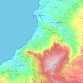
Name: Agaete topographic map, elevation, terrain.
Location: Agaete, Las Palmas, Canary Islands, Spain (28.02747 -15.74678 28.11752 -15.64658)
Average elevation: 427 m
Minimum elevation: 0 m
Maximum elevation: 1,430 m
Thank you for supporting this site ❤️
Make a donation
Make a donation