
Ιλισσός topographic map
Interactive map
Click on the map to display elevation.
About this map
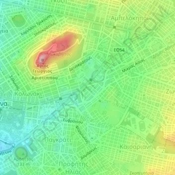
Name: Ιλισσός topographic map, elevation, terrain.
Average elevation: 140 m
Minimum elevation: 71 m
Maximum elevation: 262 m
Other topographic maps
Click on a map to view its topography, its elevation and its terrain.
Lycabettus
Greece > Attica > Regional Unit of Central Athens > Athens
Lycabettus, Δώρας Δ' Ίστρια, Kolonaki, Συνοικία Κολωνακίου, 1st District of Athens, Athens, Municipality of Athens, Regional Unit of Central Athens, Attica, 106 76, Greece
Average elevation: 125 m
Dourgouti Region
Greece > Attica > Regional Unit of Central Athens > Athens
Dourgouti Region, Dourgouti, 2nd District of Athens, Athens, Municipality of Athens, Regional Unit of Central Athens, Attica, Greece
Average elevation: 73 m
Philopappos Hill
Greece > Attica > Regional Unit of Central Athens > Athens
Philopappos Hill, Athens, Municipality of Athens, Regional Unit of Central Athens, Attica, 117 41, Greece
Average elevation: 73 m
Άλσος Βεΐκου
Greece > Attica > Regional Unit of Central Athens > Athens
Άλσος Βεΐκου, Galatsi, Athens, Municipality of Galatsi, Regional Unit of Central Athens, Attica, Greece
Average elevation: 171 m