
Make a donation
Picinisco topographic map
Click on the map to display elevation.
Make a donation
About this map
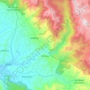
Name: Picinisco topographic map, elevation, terrain.
Location: Picinisco, Frosinone, Lazio, Italy (41.60223 13.82594 41.71901 13.97457)
Average elevation: 968 m
Minimum elevation: 345 m
Maximum elevation: 2,228 m
Make a donation
Other topographic maps
Click on a map to view its topography, its elevation and its terrain.
Monte Cassino
Italy > Lazio > Frosinone > Cassino
Monte Cassino (today usually spelled Montecassino) is a rocky hill about 130 kilometres (80 mi) southeast of Rome, in the Latin Valley, Italy, 2 kilometres (1+1⁄4 mi) west of Cassino and at an elevation of 520 m (1,710 ft). Site of the Roman town of Casinum, it is widely known for its abbey, the first house…
Average elevation: 231 m