
Thank you for supporting this site ❤️
Make a donation
Make a donation
Damüls topographic map
Click on the map to display elevation.
Thank you for supporting this site ❤️
Make a donation
Make a donation
Damüls
Damüls is situated at an altitude of 1,430 m. It has an area of 20.92 km². It borders on the Bregenz Forest, the Biosphere Reserve Großes Walsertal, the Laternsertal, and all other Vorarlberg districts (Bludenz, Feldkirch and Dornbirn). The most famous mountain peak in the area, a popular hiking destination from Damüls, is the Damülser Mittagsspitze (2,095 m).
Thank you for supporting this site ❤️
Make a donation
Make a donation
About this map
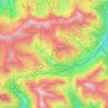
Name: Damüls topographic map, elevation, terrain.
Location: Damüls, Bezirk Bregenz, Vorarlberg, 6884, Austria (47.26787 9.82374 47.31395 9.92963)
Average elevation: 1,608 m
Minimum elevation: 1,014 m
Maximum elevation: 2,095 m
Thank you for supporting this site ❤️
Make a donation
Make a donation
Other topographic maps
Click on a map to view its topography, its elevation and its terrain.
Thank you for supporting this site ❤️
Make a donation
Make a donation
Thank you for supporting this site ❤️
Make a donation
Make a donation