
Make a donation
Tual topographic map
Click on the map to display elevation.
Make a donation
Tual
The city comprises the main Dullah Island (Pulau Dullah) together with numerous smaller islands off the north of Kei Kecil island, together with the small archipelagoes of the Tayando Islands, and Kur Islands, which lie to the west of the Kei Islands. The total land area of these islands is 254.39 km2 (98.22 sq mi). The Tayando Islands have a maximum altitude of around 100 metres above the sea, while the Kur Islands has an altitude of around 400 metres. On Dullah Island, the city has a small slope between 0 to 25 degrees, most of it generally considered to be a low-lying region. However, there are several points within the city boundaries that have steep slopes above 45 degrees.
Make a donation
About this map
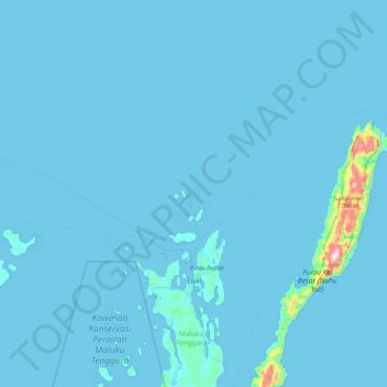
Name: Tual topographic map, elevation, terrain.
Location: Tual, Maluku, Indonesia (-5.76766 131.92606 -5.11460 132.81672)
Average elevation: 14 m
Minimum elevation: -2 m
Maximum elevation: 760 m
Make a donation
Other topographic maps
Click on a map to view its topography, its elevation and its terrain.
Make a donation
Make a donation
Make a donation
Make a donation
Make a donation
Make a donation
Batas Desa Dian Pulau Kec Kei Kecil Barat Kabupaten Maluku Tenggara
Indonesia > Maluku > Maluku Tenggara > Debut
Average elevation: 6 m
Make a donation