
Thank you for supporting this site ❤️
Make a donation
Make a donation
Colle di Sotto topographic map
Click on the map to display elevation.
Thank you for supporting this site ❤️
Make a donation
Make a donation
About this map
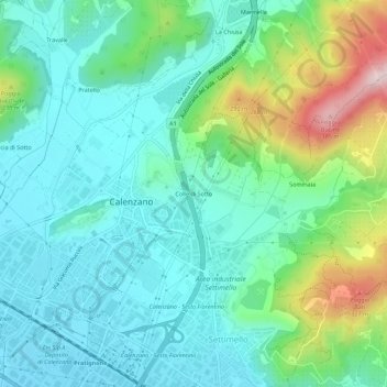
Name: Colle di Sotto topographic map, elevation, terrain.
Location: Colle di Sotto, Calenzano, Firenze, Toscana, 50041, Italia (43.84605 11.15633 43.88605 11.19633)
Average elevation: 134 m
Minimum elevation: 46 m
Maximum elevation: 399 m
Thank you for supporting this site ❤️
Make a donation
Make a donation
Other topographic maps
Click on a map to view its topography, its elevation and its terrain.
Area naturale protetta di interesse locale Monti della Calvana
Italia > Toscana > Firenze > Calenzano
Average elevation: 360 m