
Make a donation
العرب topographic map
Click on the map to display elevation.
Make a donation
About this map
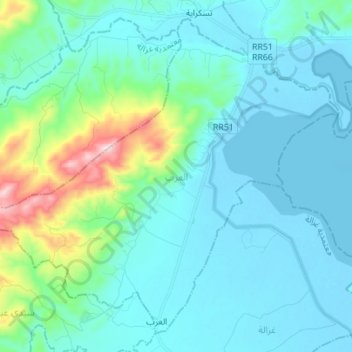
Name: العرب topographic map, elevation, terrain.
Location: العرب, معتمدية غزالة, Bizerte, Tunisia (37.10596 9.47391 37.20335 9.61250)
Average elevation: 76 m
Minimum elevation: -6 m
Maximum elevation: 496 m
Make a donation
Other topographic maps
Click on a map to view its topography, its elevation and its terrain.
Make a donation
Bizerte
Tunisia > Bizerte > بوبكر باكير
The bridge leads to the motorway A4 leading to Tunis–Carthage International Airport and the capital. On the town side the P11 passes semi-rural Louata, hugs Ichkeul Lake and branches into a western route, the P7, leading directly to Tabarka on the coast next to the Algerian border. The P11 leads south-west…
Average elevation: 28 m
Ras Jebel
Tunisia > Bizerte > رأس الجبل الشمالية
Ras Jebel is set on a hill overlooking the Mediterranean Sea. It has an altitude of 53 meters (174 ft).
Average elevation: 62 m
Make a donation