Geolocate

Geldingadalir topographic map

Click on the map to display elevation.

About this map

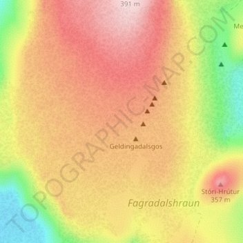
Name: Geldingadalir topographic map, elevation, terrain.

Location: Geldingadalir, Grindavíkurbær, Southern Peninsula, Iceland (63.88024 -22.28485 63.90024 -22.26485)

Average elevation: 256 m

Minimum elevation: 90 m

Maximum elevation: 382 m

Other topographic maps

Click on a map to view its topography, its elevation and its terrain.

Reykjadalur

Iceland > Sveitarfélagið Ölfus

Average elevation: 321 m

Grýtubakkahreppur

Iceland

Average elevation: 326 m

Mývatn

Iceland > Þingeyjarsveit > Reykjahlíð

Average elevation: 285 m

170

Iceland > Seltjarnarnesbær

Average elevation: 1 m

Bolungarvíkurkaupstaður

Iceland

Average elevation: 224 m

Thridrangar Lighthouse

Iceland

Average elevation: 0 m

Hornstrandir

Iceland

Average elevation: 157 m

Mosfellsbær

Iceland

Average elevation: 122 m

Vesturbyggð

Iceland

Average elevation: 195 m

Snæfellsjökull

Iceland > Snæfellsbær

Average elevation: 962 m

Reykjanesbær

Iceland

Average elevation: 23 m

Fjarðabyggð

Iceland

Average elevation: 350 m

Eyjafjarðarsveit

Iceland

Average elevation: 752 m

Grundir

Iceland > Reykjavik

Average elevation: 30 m

Eyjafjallajökull

Iceland

Eyjafjallajökull (Icelandic: (listen); lit. 'island mountain's glacier') is one of the smaller ice caps of Iceland, north of Skógar and west of Mýrdalsjökull. The ice cap covers the caldera of a volcano with a summit elevation of 1,651 metres (5,417 ft). The volcano has erupted relatively frequently since…

Average elevation: 819 m

Hnausapollur

Iceland > Rangárþing ytra

Average elevation: 608 m

Frostastaðavatn

Iceland > Rangárþing ytra

Average elevation: 602 m

Snæfellsnes

Iceland

Average elevation: 85 m

Öræfajökull

Iceland > Sveitarfélagið Hornafjörður

The summit caldera of this stratovolcano is 3 km × 4 km (1.9 mi × 2.5 mi) and the volcano is 20 km (12 mi) in diameter. It is the most southern of the volcanoes in the Öræfi volcanic belt (Öræfajökull volcanic belt), which is possibly an embryonic rift parallel and to the east of the Eastern volcanic…

Average elevation: 744 m

Reyðarvatn

Iceland > Múlaþing

Average elevation: 108 m

Þríhyrningsvatn

Iceland > Múlaþing

Average elevation: 622 m

Ísafjarðarbær

Iceland

Average elevation: 159 m

Hóp

Iceland > Húnaþing vestra

Average elevation: 12 m

Akureyrarbær

Iceland

Average elevation: 243 m

Meradalir

Iceland > Grindavíkurbær

Average elevation: 203 m

Þingeyjarsveit

Iceland

Average elevation: 663 m

Tálknafjarðarhreppur

Iceland

Average elevation: 285 m

Engey

Iceland > Reykjavik

Average elevation: 0 m