
Thank you for supporting this site ❤️
Make a donation
Make a donation
Isla Floreana topographic map
Click on the map to display elevation.
Thank you for supporting this site ❤️
Make a donation
Make a donation
About this map
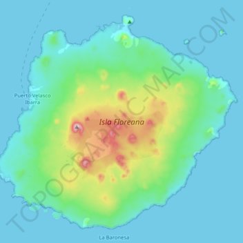
Name: Isla Floreana topographic map, elevation, terrain.
Location: Isla Floreana, Cantón San Cristóbal, Galápagos, Ecuador (-1.36016 -90.51123 -1.22026 -90.35233)
Average elevation: 91 m
Minimum elevation: 0 m
Maximum elevation: 566 m
Thank you for supporting this site ❤️
Make a donation
Make a donation