
Thank you for supporting this site ❤️
Make a donation
Make a donation
Nevado Colquepucro topographic map
Click on the map to display elevation.
Thank you for supporting this site ❤️
Make a donation
Make a donation
About this map
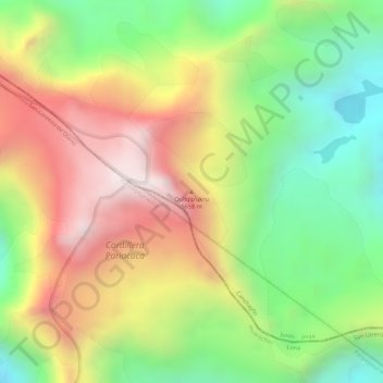
Name: Nevado Colquepucro topographic map, elevation, terrain.
Location: Nevado Colquepucro, Canchayllo, Jauja, Junín, Perú (-11.97476 -76.01911 -11.97466 -76.01901)
Average elevation: 5,291 m
Minimum elevation: 4,930 m
Maximum elevation: 5,661 m
Thank you for supporting this site ❤️
Make a donation
Make a donation