
Draa Ben Khedda topographic map
Interactive map
Click on the map to display elevation.
About this map
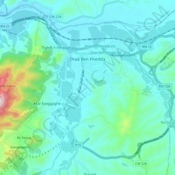
Name: Draa Ben Khedda topographic map, elevation, terrain.
Location: Draa Ben Khedda, Daïra Draa Ben Khedda, Tizi Ouzou, Algérie (36.69004 3.91159 36.75291 4.00189)
Average elevation: 105 m
Minimum elevation: 20 m
Maximum elevation: 579 m
Other topographic maps
Click on a map to view its topography, its elevation and its terrain.
Meghdoul
Algérie > Tizi Ouzou > Daïra Draa Ben Khedda > Tirmitine
Meghdoul, Tirmitine, Daïra Draa Ben Khedda, Tizi Ouzou, 15005, Algérie
Average elevation: 246 m